Showing 12 items matching department of natural resources and environment
-
 Marysville & District Historical Society
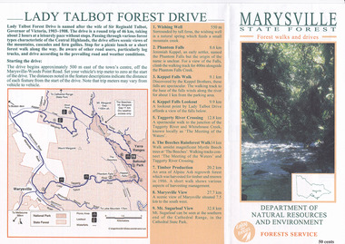
Flyer (item) - Brochure, Department of Natural Resources and Environment-Forest Service, Marysville State Forest-Forest walks and drives-Lady Talbot Forest Drive, Pre 2009
... Department of Natural Resources and Environment-Forest... victoria Department of Natural Resources and Environment-Forest ...A brochure that was produced as a guide to Lady Talbot Forest Drive in Marysville in Victoria.A brochure that was produced as a guide to Lady Talbot Forest Drive in Marysville in Victoria. Lady Talbot Drive a 24 kilometer scenic rainforest car journey which passes a number of walks and waterfalls in the Yarra Ranges National Park. Lady Talbot Drive is named after Lady Sarah Elizabeth, the wife of Sir Reginald Talbot, who was the Governor of Victoria from 25th April, 1904 to 6th July 1908.50 cents Bob McNamara/ Real Estate Agent/ Tourism Info Centre Co-Ordinatorlady talbot forest drive, lady talbot drive, sir reginald talbot, lady sarah elizabeth talbot, marysville, wishing well, phantom falls, keppel falls walk, keppel falls lookout, taggerty river, beeches rainforest walk, logging, mount sugarloaf, victoria -
 Victorian Aboriginal Corporation for Languages
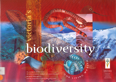
Book, Department of Natural Resources and Environment, Victoria's biodiversity : our living wealth, 1997
... Department of Natural Resources and Environment... sustainability biodiversity Victorian Alps Mallee Department of Natural ...Lush colour photographs of the particular environments, including flora, fauna, birds etc and maps locating area.Colour illustrations, colour photographsconservation, sustainability, biodiversity, victorian alps, mallee -
 Victorian Aboriginal Corporation for Languages
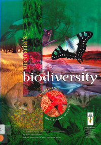
Book, Department of Natural Resources and Environment, Victoria's biodiversity : sustaining our living wealth, 1997
... Department of Natural Resources and Environment... biodiversity sustainability conservation Department of Natural ...Investigates ways of sustaining Victoria's biodiversity.Colour illustrations, colour photographsbiodiversity, sustainability, conservation -
 Victorian Aboriginal Corporation for Languages
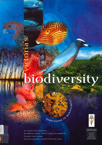
Book, Department of Natural Resources and Environment, Victoria's biodiversity : directions in management, 1997
... Department of Natural Resources and Environment... of Natural Resources and Environment ...Looking at Victoria in each region and examining the biodiversity of the environment, for management purposes.Maps (including two large maps) charts, graphs, colour photographs,biodiversity, sustainability, conservation -
 Rutherglen Historical Society
Document, 13/02/1998
... Department of Natural Resources and Environment... battery gold processing land remediation Department of Natural ...When operational, the Gold Battery used cyanide in its processing processes. The land surrounding it required remediation before it could be handed over to Indigo Shire for public use. The land has since been planted with pasture and native plants. The Gold Battery has been restored to working condition, and can be viewed by collecting a ticket from the Rutherglen Wine Experience and Visitor Information Centre.Photocopy of letter relating to remediation works on the Gold Battery site.gold battery, gold processing, land remediation -
 Greensborough Historical Society
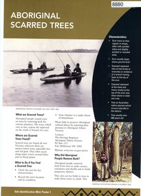
Poster, Victoria. Department of Natural Resources and Environment, Site identification mini poster (#1-2, 4-6, 8-10, 13-14), 2002
... This set produced by the Victorian Department of Natural...Victoria. Department of Natural Resources and Environment.... Department of Natural Resources and Environment Aboriginal Affairs ...This set produced by the Victorian Department of Natural Resources and Environ met and Aboriginal Affairs Victoria. Mini poster 1: Aboriginal scarred trees; 2 Aboriginal mounds; [3 missing]; 4 Aboriginal flaked stone tools; 5 Aboriginal burials; 6 Aboriginal surface scatters; [7 missing]; 8 Aboriginal ground-edge axes; 9 Aboriginal grinding stones; 10 Aboriginal stone arrangements; [11 missing]; 12 Aboriginal axe-grinding grooves; 13 Aboriginal coastal shell middens; 14 Aboriginal rock art.11 parts of incomplete set, each two sided, text and photographsaborigines - victoria, aboriginal affairs victoria -
 University of Melbourne, Burnley Campus Archives
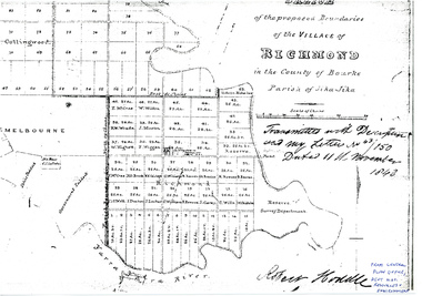
Plan - Sketch, Sketch of the Proposed Boundaries of the Village of Richmond, 1843
... of Natural Resources and Environment... Central Plan Office, Department of Natural Resources ...Sketch of the proposed boundaries of the village of Richmond in the County of Bourke Parish of Jika-Jika. Handritten, "Transmitted with Descriptioon and my letter No 43/150 Dated 11th November 1843 Robert Hoddle." Shows Burnley Gardens site as, "Reserve. Survey Department." From Central Plan Office, Department of Natural Resources and Environmentrichmond, jika-jika, robert hoodle -
 Eltham District Historical Society Inc
Folder, Victorian Goldfields Project: Historic gold mining sites in St Andrews mining division, 1999
... consultant for archealogy for the Department of Natural Resources... for archealogy for the Department of Natural Resources and Environment ...Heritage site report and gazetteer by David Bannear, head consultant for archealogy for the Department of Natural Resources and Environment. Includes information on the Warrandyte Goldfield and the Caledonia Goldfield, Queenstown (now known as St Andrews), One Tree Hill, Kingston (now known as Panton Hill), Kangaroo Grounds, You You Hill, Kingstown, South Morang, Nillumbik, (now known as Diamond Creek), Steele's Creek, Yarrambet and Kinglake. Photocopy of map headed: Location of mines and reefs from Geological survey of Victoria, Yan Yean with the Diamond Creek prominant on the map. no date35 page report with map and print out of cover letter (email form) from donorcaledonian gold fields, caledonina gold field, david bannear, gold mining, harry gilham collection, queenstown, st andrews, warrandyte goldfield -
 Victorian Aboriginal Corporation for Languages
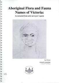
Book, Sue Wesson et al, Aboriginal flora and fauna names of Victoria : as extracted from early surveyors' reports, 2001
... the archives of the Department of Natural Resources and Environment... of Natural Resources and Environment (NRE), the State Library ...The Flora and Fauna Names Project is an initiative of the Victorian Aboriginal Corporation for Languages and the Victorian Biodiversity Strategy. The researcher has examined material from the archives of the Department of Natural Resources and Environment (NRE), the State Library of Victoria, the Victorian Public Records Office and the Australian Archives Office. This first stage of the project focussed on the NRE archives, in particular the field notebooks of the earliest surveyors and their maps although other NRE resources, libraries and public records were accessed. A total of 3028 words were found of which a significant proportion have previously been unknown to linguists. It appears that the place names and word lists in early surveyors notebooks, the 1858 surveyors responses to the Surveyor General and an extensive Wiradjuri wordlist by James Baylis have not yet been widely used or published. Fifteen percent of these 3028 words describe flora and fauna and six percent describe habitat. Of particular interest is the evidence provided by these lists of the existence of fauna in the mid nineteenth century in regions where it is now extinct. For example, magpie geese, eastern quolls, bustards and pademelons were assigned names in the Jardwadjali language area of the upper Glenelg and Wimmera Rivers. The outcomes of this project may help to assist in ascertaining the distribution of flora and fauna assets in Victoria.maps, b&w photographs, colour photographs, illustrations, word listswiradjuri, jardwadjali, glenelg river, wimmera river -
 Federation University Historical Collection
Book, Toni Woolley et al, Port Fairy Community and Organisational Plan, 1999
... department of natural resources and environment... tourism association inc moyne shire department of natural ...Port Fairy Community and Organisational Plan. University of Ballarat Students' Project.White bound book of 35 pages plus 6 appendices.port fairy, toni woolley, tamara lang, janelle gilbert, ben balshaw, grant caromody, executive summary, introduction, background to port fairy, methodology, limitations, appraisal of tourism planning and development to date, assessment of local community issues, attitudes and involvement in tourism, roles of local and regional tourism associations, effectiveness of local & regional tourism associations, analysis of services and service quality, moyne shire council, friends of port fairy, tourism victoria, country victoria tourism, great ocean road marketing, shipwreck coast tourism, port fairy tourism association inc, moyne shire, department of natural resources and environment, the western coastal board, tourism accreditation board of victoria, george borg, craig delahoy, michael hearn, jodie honan, judith kershaw, andrea lowenthal, neil martin, john ploenges, james purcell, peter strickland, mark thompson, libby wilson, michael pearlman, battle of the moyne, tourism planning, great ocean road -
 Bacchus Marsh & District Historical Society
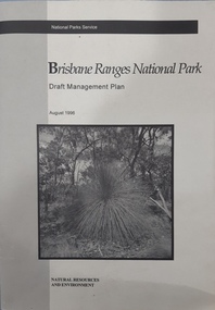
Book, Brisbane Ranges National Park Draft Management Plan
... by the National Parks Service, Department of Natural Resources ...A draft management plan for the Brisbane Ranges National Park published by the National Parks Service, Department of Natural Resources and Environment, Victoria, June, 1996.Paper book. Soft cover. A4 size.non-fictionA draft management plan for the Brisbane Ranges National Park published by the National Parks Service, Department of Natural Resources and Environment, Victoria, June, 1996. national parks, brisbane ranges national park -
 Whitehorse Historical Society Inc.
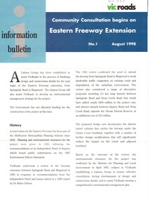
Pamphlet, Eastern Freeway Extension, 1/08/1998 12:00:00 AM
... victoria. department of natural resources and environment... of natural resources and environment environment protection authority ...Information bulletin giving history map showing features of extension,Information bulletin giving history map showing features of extension, members of liaison group established for consultation.Information bulletin giving history map showing features of extension,freeways, springvale road, nunawading, mitcham road, mitcham, park road, mullum mullum creek, deep creek road, loughnan road, ringwood, harrison street, acacia court, maroondah highway, city of whitehorse, city of manningham, city of maroondah, melbourne water, victoria. department of natural resources and environment, environment protection authority, victoria, vicroads, eastern freeway